-
Documentation
-
About
- Getting Started & Use Cases
- Support
-
What's new
- Specify basins and protrusions by drawing their outer boundary
- Simplified path features
- National Norwegian high-resolution land cover map
- Organise and communicate on a digital canvas
- New sidebar to help organize your analyses and queries
- Sliding contours
- Ny skyfallsanalys och en ännu bättre marktäckekarta
- New land cover map for Finland
- Depths in the depression map
- New Danish land cover map with more classes
- National Swedish High-Resolution Impervious Surface Mapping
- Watershed tool updated with even better descriptions of catchment characteristics
- National Flash Flood Map with Infiltration and Drainage for Denmark
- Add your own WMS layers to SCALGO Live
- Enriched building data in Denmark
- National hydrological corrections and Land Cover for Poland
- National hydrological corrections for Norway
- Updated Impervious Surface Mapping for Denmark
- National hydrological corrections and updated local data for Finland
- Fast and intuitive tools to work with infiltration and land use
- Improvements to vector imports and exports
- National Danish groundwater model
- New Sweden high-resolution model
- New powerful depression map and more analyses visualization options
- Introducing Modelspaces: Get your hydrodynamic models into SCALGO Live
- Use case videos
- Access a EA flood maps inside SCALGO Live
- Improved map export
- New powerful ways to edit the elevation model
- Better coloring of flooding layers and sea-level depth filtering
- National Danish High-Resolution Impervious Surface Mapping
- National access for local and regional organizations
- Simpler, more powerful downloads
- Customize Layer Transparency
- Hydrological corrections and new data in Sweden
- Improved export functionality
- Access a wide range of authorative data inside SCALGO Live
- Importing VASP data
- Measure gradients, undo edits, and Norway updates
- New terrain edit features, soil balance information and much more...
- Browse historical orthophotos in SCALGO Live
- Emergency planning with sea-level rise from national forecast data
- Detailed information about watershed composition
- Better styling of imported vector layers
- New Danish Elevation Model
- Work with gradients in the profile widget
- Flood risk screening from rivers and flow paths
- New workspace tool: Raise and lower terrain uniformly
- Importing LandXML TINs, LAS point clouds
- New model in Sweden
- Side slopes on workspace features
- Drag and drop enhancements
- Swedish contour maps
- Subsurface basins and sewage drains in workspaces
- New Interface
- Volume information for watersheds and flow paths
- New powerful tool for emergency response and coastal flood prevention
- Denmark: New flash flood map
- Sweden: Geodatasamverkan setting for Swedish users
- Import custom terrain models
- New Hydrological Corrections
- Elevation contours now available
- Download orthophotos as JPEG and PNG
- Subsurface structures in workspace
- Sea-levels in terrain profiles
- Updated orthophotos
- Models and analysis update
- User interface updates
- User interface updates
- GeoDanmark/FOT data, Matrikelkortet now available
- New flash flood map
- Download of risk polygons
- Updated orthophotos
- Nationwide hydrology on the new DHM/2015 model now available
- New flash flood map computation available with watershed download
- DHM/2015 variants and sea-levels now available nationwide
- DHM/2015 now available nationwide
- Hydrology on the new DHM/2015 model now available
- New DHM/2015 Model - now with buildings
- New DHM Model
- Watershed Tool
- Ad hoc layers
- Nationwide contour maps for all countries
- User Interface
- Canvas
- Analysis
- Workspaces
- Hydrodynamic Engine
- Streams and Flow
- Modelspaces
- Country Specific
-
About
User Interface – Coordinate Systems
For country-wide setups, SCALGO Live by default uses the coordinate system used by the main elevation model available for the specific country, i.e.:
- Denmark: ETRS89 / UTM zone 32N
- Sweden: SWEREF99 TM
- Norway: ETRS89 / UTM zone 33N
- Finland: ETRS89 / TM35FIN
- Great Britain: British National Grid
- Poland: ETRS89 / Poland CS92
- Germany: ETRS89 / UTM zone 32N
- Iceland: ISN2016 / Lambert 2016
- France: RGF93 v1 / Lambert-93
This is to ensure that the analysis is done directly on the raster elevation data made available by the national authorities, and the results you see on your screen match this data one-to-one.
To interact with other coordinate systems, SCALGO Live has the following features and options.
Point query results, profile exports, and coordinate look-up
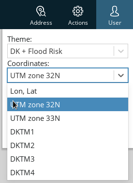
The coordinate system used for showing the results of point queries etc. can be set in the User menu in the top-right side of the screen. This also controls the coordinate system used for looking up coordinates input into the Address search bar, and when exporting profiles in a tabular format.
Note that this is not always the same as the default coordinate system for the country.
Export map
Images and PDFs generated through the Export map function always use the country-specific default coordinate system mentioned above. This cannot be changed. PDFs exported using the "Advanced" mode include georeferencing information supported by various tools to place the document correctly in relation to other georeferenced data.
Download data
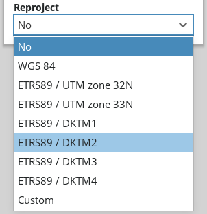
When downloading data using the Download tool and when downloading watershed areas, you can choose to either leave the data in the original coordinate system (this is the default), or to reproject it to another coordinate system of your choice. For vector data, reprojection does not have a big impact on accuracy, but raster data will (necessarily) become a little blurred when reprojecting it.
Dragging in vector data
When dragging vector data such as Shapefiles onto the dock, they are automatically reprojected to the country-default coordinate system mentioned above, so it shows in the right place with respect to other data in SCALGO Live.
This requires that the vector data is georeferenced (e.g. for Shapefiles, make sure to include a .prj file along with the .shp, .shx and .dbf files when dragging it in).
Workspaces from imported raster data
When creating a new workspace from imported raster data, the computations on the workspace will be done in the coordinate system of the raster data (to prevent loss of accuracy), but the results will be displayed in the country-default coordinate system.
Workspaces from LandXML or point cloud data
When creating a new workspace from LandXML or point cloud data, the data will be reprojected to the country-default coordinate system.
Uploading new raster data into an existing workspace
When uploading new raster data into an existing workspace, you can choose whether to keep the existing projection, or switch to the projection of the imported data.
See also the manual entry for Importing existing terrain data.
EPSG codes
To input custom coordinate systems for reprojecting data on download, or when creating a workspace, SCALGO Live uses EPSG codes. These standardized codes generally help in using the same definitions across different software packages, and are simple to input. In case you don't know the EPSG code for a projection of interest, you can look it up in online databases such as epsg.io or spatialreference.org.
Vertical references
SCALGO Live uses each country's most widely used vertical reference, which is noted in the country-specific section of the manual. When importing or exporting data no vertical reference transforms are currently being done, so you'll need to make sure data you import is in the country's standard vertical reference.