-
Documentation
-
About
- Use Cases
- Support
-
What's New
- Simplified tools for designing with contour lines
- DynamicFlood: Organize and understand your computations
- Modelling stormwater networks in Scalgo Live
- National US high-resolution land cover map
- New functionality for CAD users!
- DynamicFlood: Cleaning up rain events and adding historical rains, now available in France
- National Polish high-resolution land cover map
- DynamicFlood now available in Great Britain
- Global contour maps now available
- Updated Swedish topsoil map
- Scalgo Live Global theme is updated with new elevation and land cover data
- Detailed culvert information in DynamicFlood
- No more Lantmäteriet fees for Swedish data
- Depth-dependent surface roughness (Manning) in DynamicFlood
- Detailed land cover map for all of Great Britain
- National French high-resolution land cover map
- Work with multiple features simultaneously in the canvas
- Spill points on flash flood map and depression map
- New surface roughness (Manning) parameters for DynamicFlood
- Workspace and Modelspace sharing updates
- Regionally varying rain in DynamicFlood Sweden
- Veden imeytyminen nyt osana rankkasadeanalyysejä
- Use Scalgo Live anywhere in the world
- DynamicFlood: Live model speed info and regionally-varying rain events
- Sea-level rise: Download building flooding information
- Detailed contour maps and editable buildings in Workspaces
- New in Modelspaces: Explore hydrodynamic simulations and visualise the dynamics of flow velocity
- National German high-resolution land cover map
- Specify basins and protrusions by drawing their outer boundary
- Simplified path features
- National Norwegian high-resolution land cover map
- Organise and communicate on a digital canvas
- New sidebar to help organize your analyses and queries
- Sliding contours
- Ny skyfallsanalys och en ännu bättre marktäckekarta
- New land cover map for Finland
- Depths in the depression map
- New Danish land cover map with more classes
- National Swedish High-Resolution Impervious Surface Mapping
- Watershed tool updated with even better descriptions of catchment characteristics
- National Flash Flood Map with Infiltration and Drainage for Denmark
- Add your own WMS layers to SCALGO Live
- Enriched building data in Denmark
- National hydrological corrections and Land Cover for Poland
- National hydrological corrections for Norway
- Updated Impervious Surface Mapping for Denmark
- National hydrological corrections and updated local data for Finland
- Fast and intuitive tools to work with infiltration and land use
- Improvements to vector imports and exports
- National Danish groundwater model
- New Sweden high-resolution model
- New powerful depression map and more analyses visualization options
- Introducing Modelspaces: Get your hydrodynamic models into SCALGO Live
- Use case videos
- Access a EA flood maps inside SCALGO Live
- Improved map export
- New powerful ways to edit the elevation model
- Better coloring of flooding layers and sea-level depth filtering
- National Danish High-Resolution Impervious Surface Mapping
- National access for local and regional organizations
- Simpler, more powerful downloads
- Customize Layer Transparency
- Hydrological corrections and new data in Sweden
- Improved export functionality
- Access a wide range of authorative data inside SCALGO Live
- Importing VASP data
- Measure gradients, undo edits, and Norway updates
- New terrain edit features, soil balance information and much more...
- Browse historical orthophotos in SCALGO Live
- Emergency planning with sea-level rise from national forecast data
- Detailed information about watershed composition
- Better styling of imported vector layers
- New Danish Elevation Model
- Work with gradients in the profile widget
- Flood risk screening from rivers and flow paths
- New workspace tool: Raise and lower terrain uniformly
- Importing LandXML TINs, LAS point clouds
- New model in Sweden
- Side slopes on workspace features
- Drag and drop enhancements
- Swedish contour maps
- Subsurface basins and sewage drains in workspaces
- New Interface
- Volume information for watersheds and flow paths
- New powerful tool for emergency response and coastal flood prevention
- Denmark: New flash flood map
- Sweden: Geodatasamverkan setting for Swedish users
- Import custom terrain models
- New Hydrological Corrections
- Elevation contours now available
- Download orthophotos as JPEG and PNG
- Subsurface structures in workspace
- Sea-levels in terrain profiles
- Updated orthophotos
- Models and analysis update
- User interface updates
- User interface updates
- GeoDanmark/FOT data, Matrikelkortet now available
- New flash flood map
- Download of risk polygons
- Updated orthophotos
- Nationwide hydrology on the new DHM/2015 model now available
- New flash flood map computation available with watershed download
- DHM/2015 variants and sea-levels now available nationwide
- DHM/2015 now available nationwide
- Hydrology on the new DHM/2015 model now available
- New DHM/2015 Model - now with buildings
- New DHM Model
- Watershed Tool
- Ad hoc layers
- Nationwide contour maps for all countries
- Single Sign-On
- Data Fees
- User Interface
- Canvas
- Analysis
- Workspaces
- Modelspaces
- Working with CAD Data
- Core+ DynamicFlood
- Core+ NatureInsight
- Core+ PropertyResilience
- Streams and Flow
- Physical Properties
- Country Specific
-
About
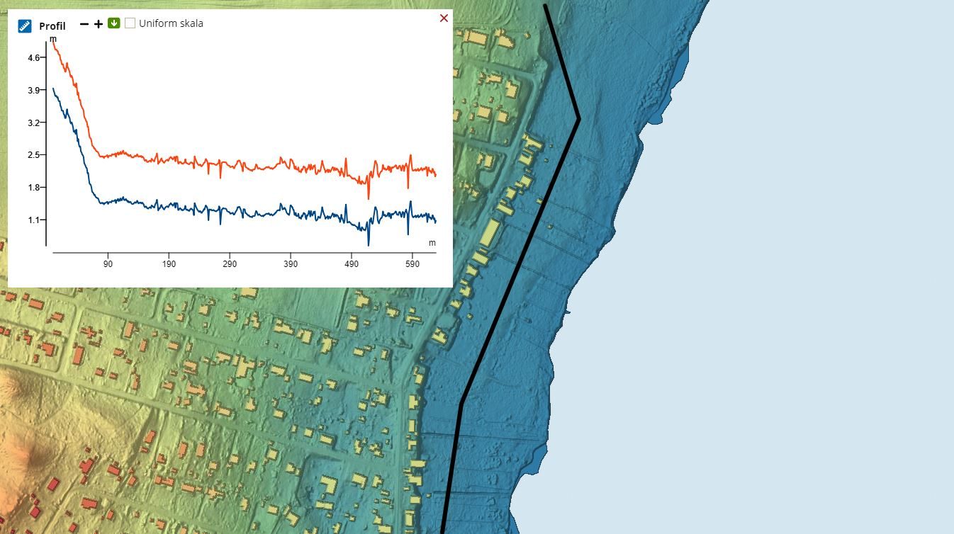
What's New – New workspace tool: Raise and lower terrain uniformly
Mar 15, 2019
We have added a new terrain edit tool for workspaces. The tool allows you to draw a path or a polygon and raise or lower all parts of the terrain covered by the object by a fixed amount. This is useful for e.g. modeling water tubes in emergency response situations where the water tube follows the terrain instead of being set at a fixed absolute elevation.