-
Documentation
-
About
- Use Cases
- Support
-
What's New
- Simplified tools for designing with contour lines
- DynamicFlood: Organize and understand your computations
- Modelling stormwater networks in Scalgo Live
- National US high-resolution land cover map
- New functionality for CAD users!
- DynamicFlood: Cleaning up rain events and adding historical rains, now available in France
- National Polish high-resolution land cover map
- DynamicFlood now available in Great Britain
- Global contour maps now available
- Updated Swedish topsoil map
- Scalgo Live Global theme is updated with new elevation and land cover data
- Detailed culvert information in DynamicFlood
- No more Lantmäteriet fees for Swedish data
- Depth-dependent surface roughness (Manning) in DynamicFlood
- Detailed land cover map for all of Great Britain
- National French high-resolution land cover map
- Work with multiple features simultaneously in the canvas
- Spill points on flash flood map and depression map
- New surface roughness (Manning) parameters for DynamicFlood
- Workspace and Modelspace sharing updates
- Regionally varying rain in DynamicFlood Sweden
- Veden imeytyminen nyt osana rankkasadeanalyysejä
- Use Scalgo Live anywhere in the world
- DynamicFlood: Live model speed info and regionally-varying rain events
- Sea-level rise: Download building flooding information
- Detailed contour maps and editable buildings in Workspaces
- New in Modelspaces: Explore hydrodynamic simulations and visualise the dynamics of flow velocity
- National German high-resolution land cover map
- Specify basins and protrusions by drawing their outer boundary
- Simplified path features
- National Norwegian high-resolution land cover map
- Organise and communicate on a digital canvas
- New sidebar to help organize your analyses and queries
- Sliding contours
- Ny skyfallsanalys och en ännu bättre marktäckekarta
- New land cover map for Finland
- Depths in the depression map
- New Danish land cover map with more classes
- National Swedish High-Resolution Impervious Surface Mapping
- Watershed tool updated with even better descriptions of catchment characteristics
- National Flash Flood Map with Infiltration and Drainage for Denmark
- Add your own WMS layers to SCALGO Live
- Enriched building data in Denmark
- National hydrological corrections and Land Cover for Poland
- National hydrological corrections for Norway
- Updated Impervious Surface Mapping for Denmark
- National hydrological corrections and updated local data for Finland
- Fast and intuitive tools to work with infiltration and land use
- Improvements to vector imports and exports
- National Danish groundwater model
- New Sweden high-resolution model
- New powerful depression map and more analyses visualization options
- Introducing Modelspaces: Get your hydrodynamic models into SCALGO Live
- Use case videos
- Access a EA flood maps inside SCALGO Live
- Improved map export
- New powerful ways to edit the elevation model
- Better coloring of flooding layers and sea-level depth filtering
- National Danish High-Resolution Impervious Surface Mapping
- National access for local and regional organizations
- Simpler, more powerful downloads
- Customize Layer Transparency
- Hydrological corrections and new data in Sweden
- Improved export functionality
- Access a wide range of authorative data inside SCALGO Live
- Importing VASP data
- Measure gradients, undo edits, and Norway updates
- New terrain edit features, soil balance information and much more...
- Browse historical orthophotos in SCALGO Live
- Emergency planning with sea-level rise from national forecast data
- Detailed information about watershed composition
- Better styling of imported vector layers
- New Danish Elevation Model
- Work with gradients in the profile widget
- Flood risk screening from rivers and flow paths
- New workspace tool: Raise and lower terrain uniformly
- Importing LandXML TINs, LAS point clouds
- New model in Sweden
- Side slopes on workspace features
- Drag and drop enhancements
- Swedish contour maps
- Subsurface basins and sewage drains in workspaces
- New Interface
- Volume information for watersheds and flow paths
- New powerful tool for emergency response and coastal flood prevention
- Denmark: New flash flood map
- Sweden: Geodatasamverkan setting for Swedish users
- Import custom terrain models
- New Hydrological Corrections
- Elevation contours now available
- Download orthophotos as JPEG and PNG
- Subsurface structures in workspace
- Sea-levels in terrain profiles
- Updated orthophotos
- Models and analysis update
- User interface updates
- User interface updates
- GeoDanmark/FOT data, Matrikelkortet now available
- New flash flood map
- Download of risk polygons
- Updated orthophotos
- Nationwide hydrology on the new DHM/2015 model now available
- New flash flood map computation available with watershed download
- DHM/2015 variants and sea-levels now available nationwide
- DHM/2015 now available nationwide
- Hydrology on the new DHM/2015 model now available
- New DHM/2015 Model - now with buildings
- New DHM Model
- Watershed Tool
- Ad hoc layers
- Nationwide contour maps for all countries
- Single Sign-On
- Data Fees
- User Interface
- Canvas
- Analysis
- Workspaces
- Modelspaces
- Working with CAD Data
- Core+ DynamicFlood
- Core+ NatureInsight
- Core+ PropertyResilience
- Streams and Flow
- Physical Properties
- Country Specific
-
About
About – What's New
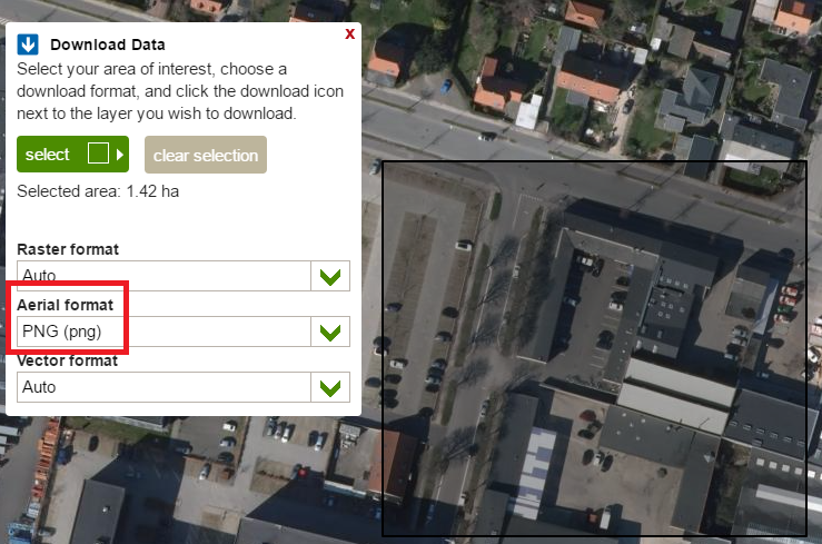
Download orthophotos as JPEG and PNG
You can now download orthophotos as PNG and JPEG files, great for working with the photos in image editing software such as Adobe Photoshop. Note that orthophotos are high-resolution and therefore very large, if you download a large area (e.g. larger than 1 km2) you are likely to run into issues when opening it in an image editing program.
Subsurface structures in workspace
You can now create subsurface structures in workspaces. Using subsurface structures, you can simulate pipes and culverts without deforming the surface of the terrain model - thus flow on top of the subsurface structure is preserved. For more information read the announcement (in Danish).
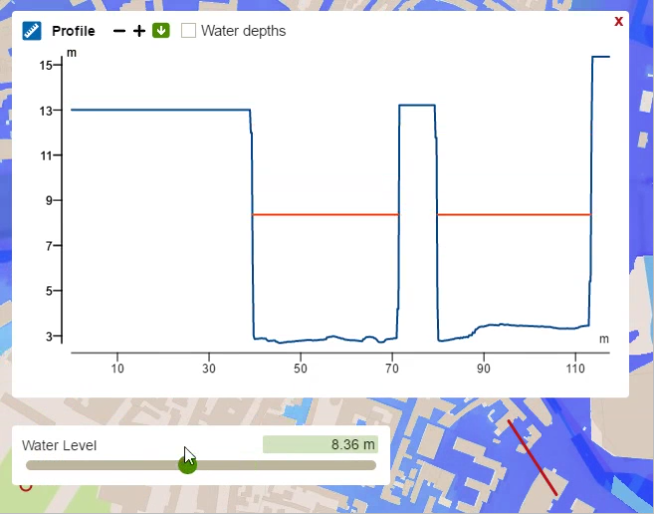
Sea-levels in terrain profiles
We have added the sea-level to terrain profiles and changed the terrain profile tool such that the water level in the profile is continuously updated as the sea-level slider changes. This also works for the Flash Flood map.
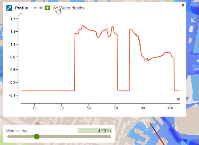
Toggle between relative and absolute water depth
Relative water depths are shown on top of the terrain elevation. Absolute water depths are shown independently of the terrain.
Continuously updated point query results
Point query results are continuously updated when changing slider value.
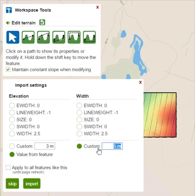
Improved feature imports
When importing a terrain feature (by dragging a shapefile to the select tool of a Workspace), you can now choose between either using the elevation and width from an existing field on the feature or using a custom value declared in the UI.
Improved download names
Using the address data from DAWA we have improved the names of downloaded files by including a reverse geocoded name in the filename. This means that filenames will contain the name of a nearby street, city or region which makes it easier to distinguish between multiple downloaded files.
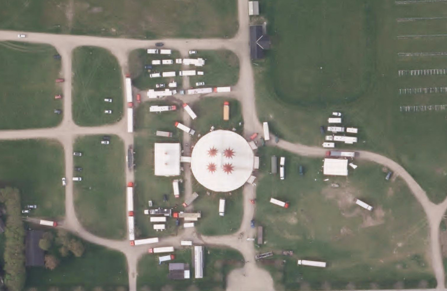
Updated orthophotos
The new nationwide orthophotos from spring 2016 are now available in SCALGO Live for both visualization and download.
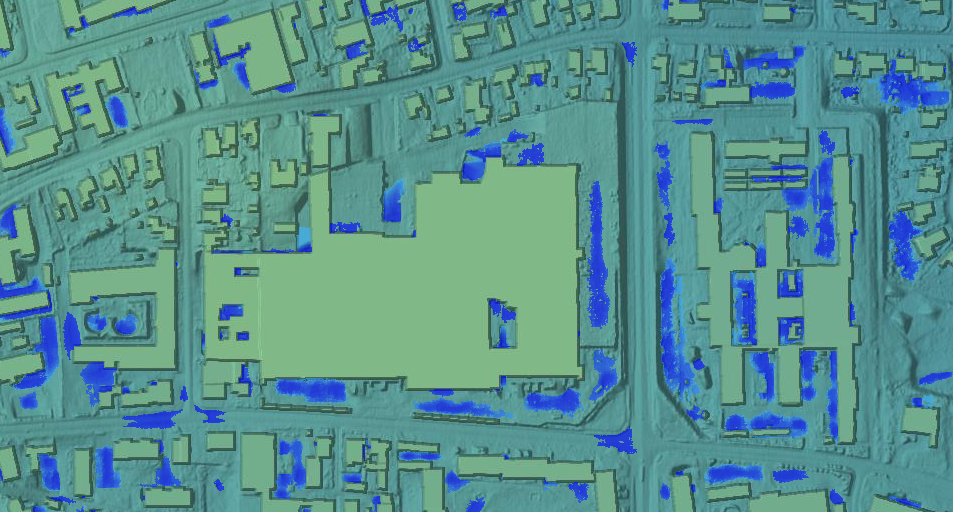
Models and analysis update
We have updated the elevation models and the analysis products (flash flood map, flow accumulation, watersheds and sea-level rise) to include newer buildings from GeoDanmark - acquired on August 4 2016 from Kortforsyningen. Your existing workspaces have not been changed.
User interface updates
We have added a number of features to SCALGO Live. Significant items in this release include:
Address search
You can now navigate to an address using the new address search bar
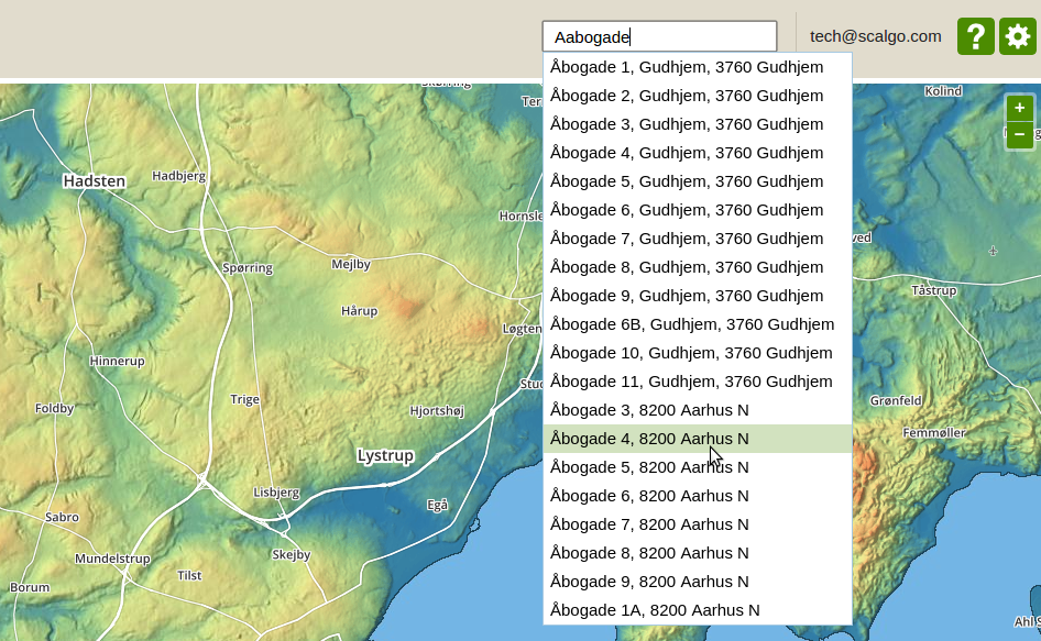
The source of the address data is DAWA, we have also switched to DAWA for the creation of workspace names. To facilitate this change, the SCALGO Live instance switcher has been moved. Users that have access to multiple SCALGO Live instances will find the switcher in the gear menu in the top right.
Single Sign-On Support
We have implemented support for SAML-based single sign-on (SSO). If your organization wishes to use SSO for SCALGO Live please contact support for guidance.
User interface updates
We have added a number of features to SCALGO Live, fulfilling a number of popular feature requests:
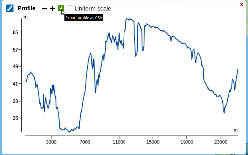
Profile exports
You can now export profiles as CSV files, making it easier to import and graph the data in third-party tools. The export is initiated by hitting the green download icon in the profile window.
Moving features
You can now move entire workspace features at a time. To move a feature, use the select tool to select a feature, then press and hold the shift button while dragging the feature with the left mouse button to move it. To move polygons you can also place the mouse cursor in the interior of the polygon and drag the polygon with the left mouse button to move it.
Login improvements
You no longer stay on SCALGO Live Global upon logging in, instead you are automatically transferred to your Live Flood Risk page. Furthermore, workspaces are now folded by default (unless you're following a link displaying a layer from a workspace, in which case that particular workspace is unfolded).
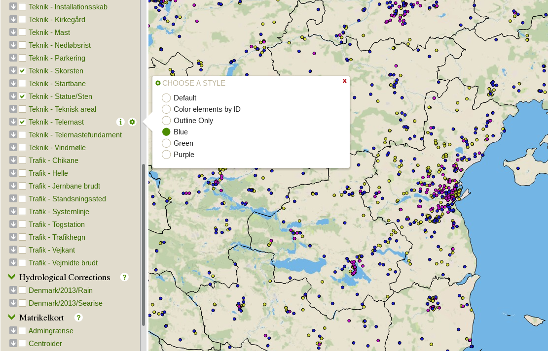
GeoDanmark/FOT data, Matrikelkortet now available
The Danish Agency for Data Supply and Efficiency (SDFE) regularly releases extracts of a number of topographic and administrative geodata products including polygons representing the boundaries of the administrative subdivisions in Denmark (DAGI), topographic base data with road, railroad, and stream geometries, buildings, and much more (GeoDanmark/FOT), as well as Denmark's digital cadastral map (Matrikelkortet). From now on these datasets are fully accessible in SCALGO Live, including fast download of local extracts. The datasets will be updated regularly in the future. Along with this release the following changes have been made:
- The "Administrative Borders" category is renamed to "DAGI".
- All layers from the "Vector Subdivision" category can now be found in the "GeoDanmark" category.
- The "DHyM Tilpasninger" layer is replaced by two layers in the new "Hydrological Corrections" category: "Denmark/Rain" and "Denmark/Searise", representing the set of hydrological corrections based on the old national Danish elevation model DHM/2007.
- We have enhanced the display options. For example, the items in a GeoDanmark vector layer can be colored differently by their "FOT ID" to easily distinguish different objects, or uniformly in yellow, green, purple or blue to distinguish different layers. Polygonal data can be displayed with their outline only, so other data can be seen in the background.
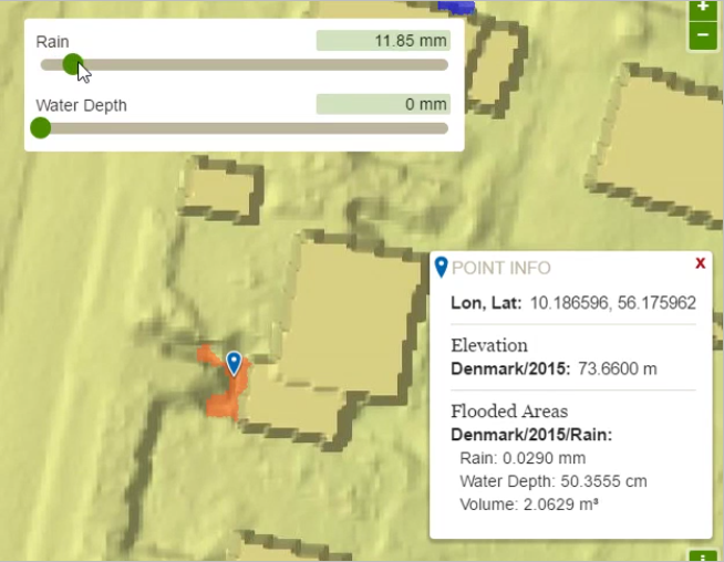
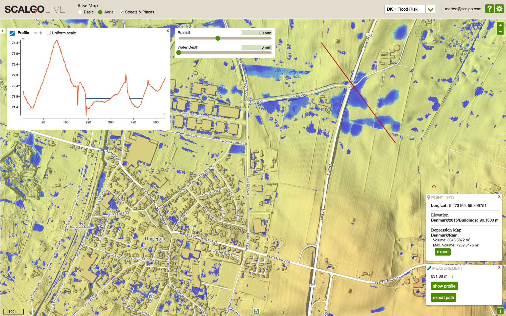
New flash flood map
We are excited to announce a new major upgrade to the flash flood map in SCALGO Live. The new flash flood map is simpler to use and offers several benefits:
- You can query, download and visualize the water depth in a depression.
- You can easily get the volume of a depression, and the water volume in the depression.
- You can view watersheds and flow for any amount of rain.
- More powerful watershed queries highlighting the downstream sink of the query point.
Read more about the new flash flood map here (in Danish).
Download of risk polygons
For certain raster-based flooding layers (e.g. sea-level rise, flooded areas of a Flash Flood Map, etc.), flood masks can now be downloaded as polygons. The polygons are simplified to greatly reduce file size and feature complexity and this makes them ready for use in GIS tools such as MapInfo, or as a basis for automated vector-based risk analysis and early-warning systems. Multiple thresholds can be specified to efficiently generate flood masks for different events, and the amount of simplification can be specified to control the complexity of the generated mask polygons.
